Filter by Industry
Filters
Industry
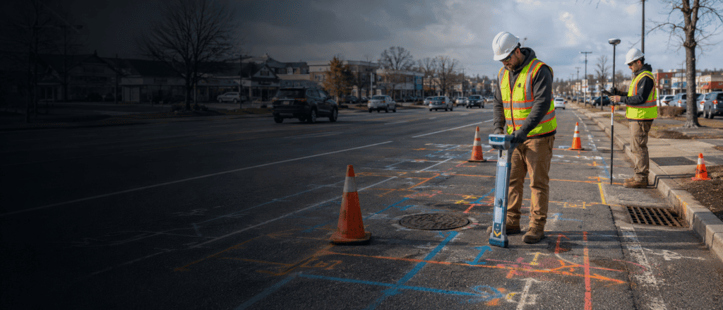
Long Island Utility Markouts, GIS Mapping & CAD Integration for Utility Coordination
Energy, Utilities
Project Overview SoftDig supported PSEG Long Island on the Elwood Phase 2 project along Laurel Avenue in Long Island, New York. The work included utility designation, records research, surveying support,…
Memorial Avenue Reconstruction Utility Mapping & SUE
Transportation
Location West Springfield, MA SoftDig supported the Memorial Avenue Reconstruction Project by delivering subsurface utility engineering (SUE), utility mapping, CCTV inspections, and hydro jetting across a heavily trafficked commercial corridor.…

Ørsted Skipjack Onshore Cable Route Utility Mapping & SUE
Energy
SoftDig supported Ørsted’s Skipjack Wind project by delivering subsurface utility engineering (SUE), utility mapping, and GIS integration across a 27-mile onshore cable route in Southern Delaware. The project required accurate…

West Goshen Township
Municipalities
Municipal Stormwater & Utility Infrastructure Asset Mapping Project Overview SoftDig partnered with West Goshen Township on a comprehensive municipal infrastructure program focused on inspection, mapping, and long-term asset management of…

Citizens Bank Park
Commercial, Sports & Entertainment Facilities
Subsurface Utility Engineering (SUE) & GIS Utility Mapping Project Overview SoftDig delivered comprehensive Subsurface Utility Engineering (SUE) and GIS Utility Mapping services at Citizens Bank Park in Philadelphia, supporting ongoing…

Manhattan Psychiatric Center
Performed underground utility markouts via RF/EM & GPR geophysical methods to detect all utilities in a ± 3.75-acre site on Wards Island. Provided detailed drawings depicting all utilities detected and…

SUNY New Paltz
Education
Performed underground utility markouts via RF/EM & GPR geophysical methods to clear borings and test pits. Provided drawings depicting all utilities detected and field marked.

PS 143Q
Education
Performed underground utility markouts via RF/EM & GPR geophysical methods covering a ±1.0 acre site and 635 LF of adjacent road ROW. Provided detailed drawings depicting all utilities detected and…

SUNY Binghamton
Education
Performed 27 test holes via typical air vacuum excavation methods and QLA processes. Provided detailed test hole reports depicting findings. Provided simple traffic control for test hole locations in the…

SUNY Alfred
Education
Performed underground utility markouts via RF/EM & GPR geophysical methods at two locations. Performed test holes via typical air vacuum excavation methods and QLA processes as well as two slit…

Con Edison Astoria to Rainey
Energy
Conducted subsurface utility location along a 50 ft wide corridor, covering approximately 18,480 linear feet. Coordination with the client and traffic control ensured smooth project execution.

Garasches Lane
Transportation
Underground Services, Inc. was tasked with obtaining and mapping SUE projects for Delaware Department of Transportation. Serving as prime consultant on this Shared Use Path project, USI personnel contacted utility…